
Radiational Cooling at Westhampton Beach, NY (KFOK)
Clear and calm nights are meteorologically notable for allowing Earth’s surface to cool with maximum efficiently. The term used to describe nights where these conditions are present is Radiational cooling. The lack of clouds is ideal for Earth’s radiated energy to escape to space, while calm winds in a stable boundary layer help to minimize mixing of the air near Earth's cooling surface. These conditions are frequently promoted by synoptic-scale anticyclones (high pressure systems) situated in the Eastern third of the US.
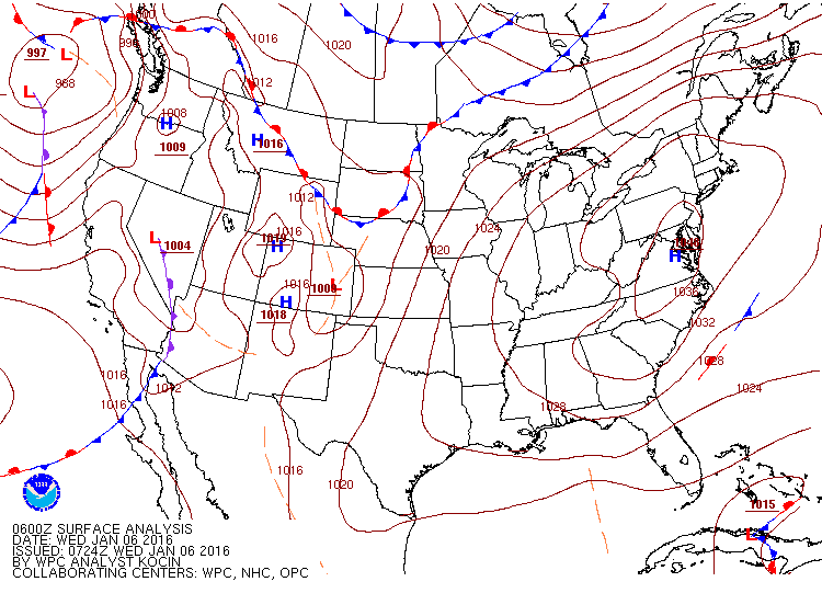
The National Weather Service surface analysis below is valid for 1am (EST) on Wednesday, January 6. Evidence of a cold, dry air mass is represented by the large high pressure system centered near Washington, DC. Subsidence and a weak pressure gradient beneath the sprawling high contributed to widespread clear and calm/light winds during the overnight hours throughout the region.
Why clear and calm?
The impact of clouds on incoming solar radiation is readily apparent to any casual observer. However, many do not realize that clouds also play a major role in regulating outgoing terrestrial radiation. Clouds reduce the amount of radiation that is otherwise allowed to escape to space by reflecting and reradiating infrared energy (heat) back towards Earth's surface. This process is simplified in the diagram below.

(Image credit: NOAA)
During the overnight hours while energy escapes from Earth’s surface the atmosphere nearest ground level cools faster than air just above. When winds are calm the air near the surface is allowed to cool without mixing with the now relatively warmer air aloft, or air from surrounding areas. If these conditions persist for a few hours an extended period of cooling can drop surface temperatures significantly. This is especially true if the air and soil are dry. The soil composition at Westhampton Beach is precisely what makes it the king of radiational cooling on Long Island.
Why such rapid cooling at Westhampton Beach (FOK)?
The Pine Barrens region (of which FOK is a part) has porous, sandy soil that allows precipitated water to easily infiltrate to great depths. This reduces water storage near the surface. The low soil moisture allows for rapid changes in surface temperature and, under the right conditions, the air near the surface as well. It is not uncommon to find FOK reporting temperatures 10 to 15 degrees cooler than surrounding suburban sites, and sometimes 20 to 30 degrees cooler than nearby urban (New York City) or coastal locations (Montauk). A recent example is shown in the graph below.

Explanation of some notable features on this graph:
A: The passage of an arctic front ushered in gusty NW winds and clear skies. Persistent NW winds throughout the night promoted a well-mixed boundary layer region-wide, with nearly uniform low temperatures at all three sites.
B: Cold air advection continued through the day, but note the rapid response in the temperatures at FOK once the sun came up. However, daytime highs were comparable at all three locations.
C: Winds go calm at FOK around sunset and rapid radiational cooling takes hold. By 6 a.m. there is a 25°F temperature difference between FOK and NYC, and a 14°F difference between FOK and ISP.
D: Between 8 a.m. and 9 a.m. the temperature at FOK jumped 18°F as the sun came up and winds began to mix out the cold air near the surface. By 10 a.m. the total increase in surface temperature was 29°F over the two hour period.
It has been noted in a study conducted by Ashley Sears at NWS WFO-OKX that light winds are more important than clear skies in these extreme radiational cooling events at FOK. This is consistent with the observations above, as the morning of January 5th had clear skies with gusty winds resulting in comparable low temperatures at all three sites. The morning of January 6th, however, featured 15 consecutive hours of calm winds at FOK (6 p.m. on the 5th to 8 a.m. on the 6th) resulting in a classic Westhampton Beach radiational cooling event.